Dixon Creek is named after William Fooks Dixon, who owned the northern half of Corvallis, then named Marysville.
Pre-1800 – In the Kalapuya era, Dixon Creek was comprised of many headwater streams rushing down the hills to the north. The beaver-inhabited creek in the lowlands was almost entirely wetland and braided corridors, with no discernible single channel. The plentiful beaver dams kept the waterway full even during severe droughts.
1800s – With the settlement of Euro-Americans, the beavers were trapped to extinction and the wetland-creating dams were destroyed. The creek beds were incised by the faster flowing creek water and further trenched by farmers as drainage channels. As the creek beds were scoured and trenched, the water table dropped with it, further drying out the wetlands. The farmers installed agricultural tiles (underground drainage pipes) in their farmland to further dry out the land, leaving mostly arid land in the summer. All of Dixon Creek was a hydrological system unrecognizable in its form, function and ecological health from what it was in the 1700s.
1900s – The middle and upper reaches of the watershed did not get developed into residential property until the mid and late 20th century. All that remains to be developed in the watershed are the very upper reaches. Developers are working hard to develop those areas that are not publicly owned. Only the very top of Dimple Hill and the ridgeline toward Chip Ross Park are currently protected from development. During this era, the creek became a rapid-response, high-speed stormwater conveyance system, fed by miles of stormwater pipes, which were, in turn, fed by roads, buildings, paved sidewalks and other paved surfaces. Each of these impervious surface types fed almost all of its water instantly to Dixon Creek and the water was filled with the thousands of human-made chemicals and waste that are found on those surfaces. Dixon Creek further devolved into a hydrological system unrecognizable in its form, function and ecological health from what it was in the 1800s.
2000s – While there is growing understanding of the need to regenerate healthy, productive creeks, the top City priority for Dixon Creek is that is remains a rapid-response, high-speed stormwater conveyance system. Greater pressures to increase housing development, wider roads and large-capacity stormwater pipes and culverts is a recipe for further degeneration of creek health and functionality. Small creek sections on public land adjacent to Dixon Creek have been replanted with native vegetation, but hydrological and ecological health conditions of the creek continue to degrade.

Dixon Creek Statistics
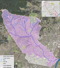
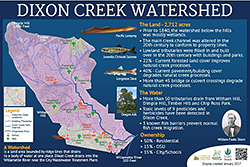
- 2,712 acres – Dixon Creek is one of the largest creek watersheds within the City of Corvallis.
- 6 miles long – Measured from its highest and furthest perennial flow source, down to its outfall into the Willamette River
- Highest point – 1,480 ft at Dimple Hill
- Lowest point – 200 ft at its confluence with the Willamette River by the City wastewater treatment plant
- Main tributaries – East, Middle and West Forks in the foothills from Dimple Hill to Chip Ross Park (all remaining tributaries including those from Witham and College Hills have been covered or piped)
- Flow Patterns – High in winter, lower in spring, very low in summer, almost dry in fall until the rains restart
- Ownership – Fifteen percent OSU McDonald Forest, 15% open space (subject to development), 30% low density residential, 15% medium density residential
- Paved or built impervious surfaces – Over 35% of the entire Dixon Creek watershed (over 950 acres) is covered with pavement or buildings.
- Over 33 creek bridges – Crossed by many roads and bridges with buildings so close to the creek banks makes Dixon Creek one of the most engineered creeks in Corvallis.
- Redirected, channelized, deeply incised – Dixon Creek has been moved from its original creek course multiple times, often to adjust to changing property lines. The channel has been deepened by construction equipment and has been further deeply incised downward from excessive, high-velocity and high-volume stormwater drainage from the City’s municipal stormwater piping system that drains unchecked into Dixon Creek.
- Pollution status – A 2003 study by the Conservation Biology Institute found in Dixon Creek high levels of nine pesticides that are harmful to fish. These pesticides generally enter the stream in stormwater runoff from neighboring homes, businesses and institutions.
- Fish barriers – The most significant fish barrier is at the confluence of the creek with the Willamette River. The steep stone embankment accompanied by a relatively low outlet flow rate only allows fish passage during high flow rates during storms. The double box culverts under 27th Street and 29th Street also display high blockage levels during non-rain event days.
- Wetland loss – The lowlands of Dixon Creek previously served a continuous thread of wide productive wetlands, filled with fish and a broad diversity of native aquatic and terrestrial animals and plants. The human-made channelization of the creek drained and destroyed most of the wetlands, leaving a dearth of original aquatic species. There are a few tiny wetlands remaining in the lower headwater areas and in the Willamette River floodplain area.
- Fish in Dixon Creek – Cutthroat trout, Pacific lamprey and long-nosed dace inhabit Dixon Creek. During Willamette River flooding, Chinook salmon find refuge in the lower Dixon Creek floodplain, including Washington Park.
Watershed Boundaries
- Northern boundary – Over 40 headwater tributaries on its northern watershed boundary drain into Dixon Creek from Dimple Hill on the west, stretching east to Chip Ross Park.
- Western boundary – The western watershed boundary is the eastern slope of Witham Hill. Water drains quickly down steep paved roads into the lowlands.
- Southern boundary – The southern boundary is essentially flatlands. Former streams and wetlands that drained into Dixon Creek were filled in to accommodate housing and business development. Storm drains have now replaced those tributaries.
- Eastern boundary – Dixon Creek drains to the east into the Willamette River, adjacent to the City’s wastewater treatment plant. The Willamette River is the eastern boundary.
Water Action Team Activities in Dixon Creek

- Partnered with the City to work with property owners adjacent to Dixon Creek to remove invasive weeds and plant native species
- Planted trees and shrubs to expand the vegetative buffer along Dixon Creek at Porter Park, Kathryn Jones Harrison Elementary School and Corvallis High School
- Led two bike tours of Dixon Creek
- Designed, printed and installed two Dixon Creek Interpretive Displays along Dixon Creek at Corvallis High School and Harrison Elementary School
- Served as a resource on creek history and statistics for a published article about Dixon Creek, to a citizens’ group attempting to save a Dixon Creek wetland in the lower floodplain area, and to a neighborhood association trying to preserve a Dixon Creek wetland in the headwaters area
- Discovered and researched the lost tributaries of Dixon Creek
2022 Water Action Team Workplan
- Maintain the native revegetation project along Dixon Creek by Corvallis High School and Buchanan Avenue
- Continue to work with City staff toward viable creek regeneration solutions
- Create a webinar devoted to interpreting Dixon Creek for the general public

