Goal
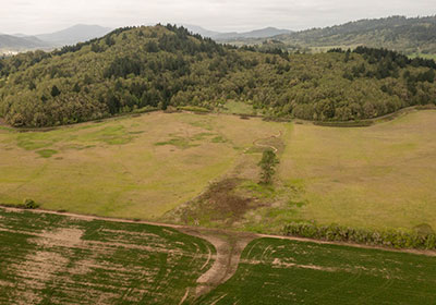
To resurrect a section of the North Branch of Dunawi Creek on the City-owned Bald Hill Natural Area east field that had been buried underground in agricultural drainage tile pipes over 100 years ago and reconnect the above-ground flow of the headwaters to the downstream corridor with a natural creek hydrology of a braided, meandering waterway interspersed with wetlands and vernal pools and surrounded by native riparian and wetland plant and animal species.
Background
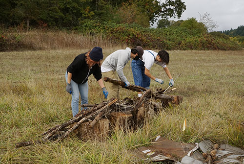
In 2016, the Water Action Team (WAT) requested and the City of Corvallis government and landowner of the Bald Hill Natural Area agreed that the WAT could proceed with the project as long as the team provides the funding and labor for the project and the City approved the work to be done on the City property. The whole east field is lined with loosely-connected, 2-foot long, terra cotta pipes located about 4-feet below the soil surface. The pipes suck the water out of the soil and drain it downstream, leaving the top 4 feet of soil sufficiently dry in winter for farming. This process, however, is damaging to the natural ecology of a natural area. The most effective way to decommission the pipes and allow a naturally functioning hydrology is to make lateral cuts of the pipe about every 50 feet of pipe length. Prior to decommissioning, it was necessary to replant the commercial ryegrass with native riparian and wetland species to stabilize the soils and provide food and habitat for native fauna. To limit incisive erosion from the newly resurrected creek, creek diversion structures have been installed to divert water into braided channels and to create pools and riffles for biodiversity. The 10-inch culvert under the Bald Hill Natural Area is significantly undersized to convey the flow of the headwaters and gravels off Bald Hill into the lower field. An 8-foot-wide culvert was recommended by stream engineers.
Accomplishments 2016-2022
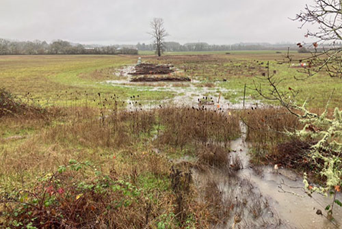
- Planted over 7,000 native shrubs, perennials, graminoids and grasses
- Installed 12 creek diversion structures
- Cut and plugged 12 drainage pipes
- Provided on-going mulching, watering and weeding maintenance of planted areas
- Instructed hundreds of high school and university students on work-study projects
- Received conceptual approval for culvert replacement
- Cut and planted 200, three-foot Pacific Willow stakes from a grove at Bald Hill Natural Area and plant them on the upstream side of the 12 creek diversion structures
- Expanded length of existing 12 creek diversion structures
2022 Work Plan
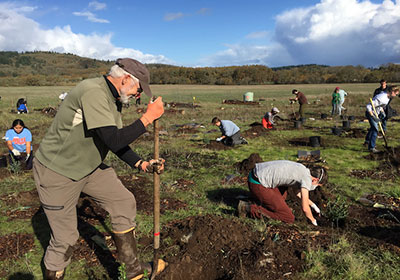
- Build four additional creek diversion structures (Spring/Summer)
- Contract construction company to replace Bald Hill Multimodal Path culvert with larger pipe (Spring)
- Replace culvert (Summer)
- Cut and plug six more drainage pipe sites (Summer)
- Water, weed and mulch native plants under two years old (Summer)
- Plant 400 native species (November)
Two Corridors
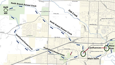
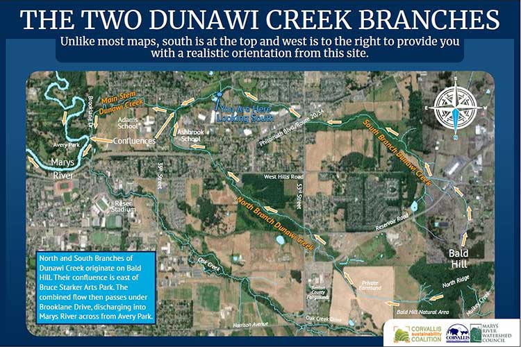
Dunawi Creek starts at Bald Hill, just west of the Benton County Fairgrounds, and drains into two branches, the North Branch and the South Branch.
- The North Branch of Dunawi Creek flows:
- East off the east slopes of Bald Hill and the north ridge of Bald Hill,
- East across first City Natural Area fields and then private property toward the Fairgrounds,
- Turns south near the west property line of the Fairgrounds, crosses under the Midge Cramer Trail, Reservoir Road, the former Reservoir Road and the railroad trestle,
- Turns east under 53rd Street across private property and through First Congregational Church property,
- Turns south and under West Hills Road, across private properties and under Philomath Blvd. where Western Avenue meets Philomath Blvd. and
- Flows southeast until its confluence with the South Branch between the multimodal path and 35th Street.
- The South Branch of Dunawi Creek flows:
- South off the south slope of Bald Hill and crosses under Reservoir Road and West Hills Road,
- Turns southeast under SW Winding Way Road across private land and crosses under 53rd Street immediately to the north of Philomath Blvd.,
- Turns south under Philomath Blvd., and then southeast through the BiMart/Safeway parking lots, under SW Reservoir Loop and through Bruce Starker Arts Park and under SW 45th Street and SW Research Way, and
- Turns north until its confluence with the North Branch to the south of the multimodal path that extends to 35th Street.
- The Main Stem of Dunawi Creek flows:
- East from the confluence of the North and South Branches, under SW 35th Street and under SW Knollbrook Place,
- Turns north just before it reaches SW Brooklane Drive, traverse along the west side of Brooklane Drive, and
- Turns west and under Brooklane Drive and then immediately drains into the Marys River directly across from Avery Park, about 300 yards south of the confluence of Oak Creek and the Marys River.
The Name – Dunawi
Dunawi Creek was named in 2003 after the Kalapuyan word for female elders. Before that, the creek was named Squaw Creek. Because “squaw” has offensive connotations, Colleen Roba and Olivia Wallulatum of the Warm Springs Tribal Office of Government Affairs successfully lobbied the name change with the support of OSU Doctoral Anthropology student Suzanne Fluharty. They encouraged collaboration and received support from the Confederated Tribes of Siletz Indians, Confederated Tribes of the Grand Ronde, Oregon Geographic Names Board, Benton County Board of Commissioners, Corvallis City Council, plus Oregon and U.S. officials.
Numbers
- 2,363 acres – The Dunawi Creek watershed drains over 25% of the City of Corvallis.
- 2 miles long – The creek corridor length is measured from Bald Hill down to its outfall into the Marys River, and includes both the length of the North Branch and its relatively parallel South Branch.
- Highest point (755 ft) – Bald Hill is the source of both the North and South Branches of Dunawi Creek. Other headwater tributaries originate from the lower Grand Oaks Hill and Country Club Hill (formerly known as Oak Butte and Weigand Hill).
- Lowest point (212 ft) – Dunawi Creek’s mouth at its confluence with the Marys River across from Avery Park is the lowest point in the watershed.
- Land Uses – 33% of the watershed is low-density residential & 26% is open space.
- Paved or built impervious surfaces (over 35%) – Over 762 acres of the watershed is covered with pavement or buildings.
- 23 creek bridges/culverts – Dunawi Creek is crossed by a road or pedestrian bridge about every 1/5 of a mile. A planned development near 53rd Street will increase the current number of bridges/culverts.
Characteristics
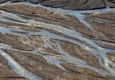
Redirected, channelized, deeply incised: Before Euro-American settlement, the creek was a combination of braided, ever-changing shallow channels flowing through a series of extensive wetlands. Since Euro-American settlement, the braided creek, wetlands, and tributaries have been covered over with dirt, bridged, channelized, piped and moved from its original course. The remaining drainage channel has been deepened by human labor and has been further incised downward from excessive, high-velocity and high-volume stormwater drainage from the City’s municipal stormwater piping system. The confluence of the North and South Branches was reconfigured into its highly unnatural perpendicular configuration to conform with property boundaries.
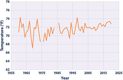
Pollution status: Elevated creek water temperature is one of the most ecologically damaging forms of pollution for native fish in Dunawi Creek. Because portions of the creek are exposed to full sun, summer solar radiation elevates the water temperatures to levels, making it difficult for native fish to survive. Other pollutants include volatile organic compounds (VOCs) and over 80,000 human-made pollutants that can run into the stormwater system and directly into Dunawi Creek.
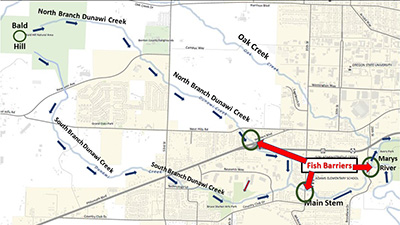
Fish barriers: A significant fish barrier at the confluence of the creek with the Marys River prohibits many native fish from entering this watershed. The steep, human-constructed stone embankment only allows fish passage during high flood levels. In addition, an elevated culvert runs under 35th Street by Adams Elementary School, blocking further fish passage. A private fish barrier dam is located on the North Branch immediately north of Philomath Blvd. Reduced beaver activity and wetland acreage has resulted in lower water availability for the creek during dry seasons, further inhibiting fish habitat.
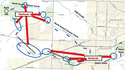
Wetlands: The Dunawi Creek watershed has a higher percentage of remaining wetland acreage than any other Corvallis creek. These wetlands, however, are at great risk from residential, commercial, and governmental development pressures.
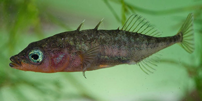
Fish in Dunawi Creek: Investigations discovered Oregon chub, three-spined stickleback, redside shiners, and sculpin. The fish biomass was dominated by the non-native invasive species western mosquitofish and predatory bluegill.
Boundaries
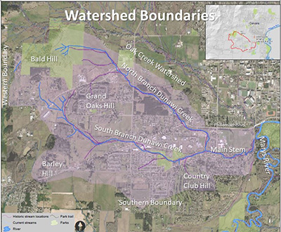
Northern Boundary: Bald Hill is located at the northwest corner of the watershed, draining southeasterly on lowlands bordering Oak Creek’s southern watershed boundary. The northern watershed border from Bald Hill to Philomath Blvd. parallels a line halfway between the North Branch and Oak Creek corridors. Once the main stem of Dunawi Creek crosses SW 35th Street, Philomath Blvd. is the northern border of the Dunawi Creek watershed all the way to Brooklane Drive.
Western Boundary: Near Rosecrest Drive off SW West Hills Road
Southern Boundary: Four hills (380 ft, 300 ft, 300 ft and 460 ft elevation) line the southern border from Barley Hill to Country Club Hill (formerly called Oak Butte and Weigand Hill).
Eastern Boundary: Creek outfall into the Marys River, along SW Brooklane Drive
Water Action Team Activities in the Dunawi Creek Watershed
- Dunawi Creek Regeneration Project: This Water Action Team project reconnects the headwaters of the North Branch with its downstream corridor by the Fairgrounds. The project is decommissioning underground drainage pipes, replacing a small culvert under the multimodal path, replanting the riparian zone with native riparian species, building creek diversion structures, and creating vernal pools and extended wetlands. Portions of the project are explained in more detail in the following video, particularly starting at the 27-minute time code.
- Starker Arts Filtering Wetland: This South Branch project regenerates an ancient wetland that had been drained and overgrown by invasive weeds. We regraded the drainage to stay in the wetland, replanted the site with native wetland species, and introduced decaying woody material for habitat and soil regeneration. We are mulching, watering, and weeding until the site is self-maintaining. We designed, printed, and installed six interpretive displays. (See Starker Arts Filtering Wetland).
- Mapping: We researched and documented the Lost Creeks of Dunawi Creek, working with the City to post a GIS map of the lost creeks. (See Corvallis Lost Streams (arcgis.com)
- Displays: We developed interpretive displays for Bald Hill Natural Area and Starker Arts Park, depicting the Dunawi Creek Watershed and the regeneration of lost tributaries. (See graphic below.)
- Tours: We partner with other organizations to lead tours of Dunawi Creek. (See brochures from past tours below.)
Resources
- City of Corvallis Salmon Response Plan
- City of Corvallis Stormwater Master Plan (see chapters 4.2.1 and 6.0-6.3)
- 2012 In-Stream Temperature Monitoring Report

