Goal
Create a contiguous wildlife and pedestrian corridor for the Mill Race that extends from SW Allen Street to the Marys River below the BMX Park
Background
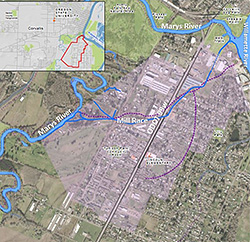
The Mill Race is a 1.2-mile trenched waterway in South Corvallis that generally follows the topography of an original Marys River shallow overflow channel. The Mill Race now follows the course from the Marys River near the south end of SW Allen Street. It flows to the northeast to reconnect to the Marys River at the City of Corvallis BMX Park, near the Marys River confluence with the Willamette River. Built in the 1850s under the direction of J.C. Avery, the Mill Race system consisted of the following components:
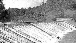
- A dam was built across the Marys River at the current site of the Boy Scout Lodge off Allen Street. Portions of this dam still exist on church-owned property housing the Boy Scout Lodge.
- A reservoir was created by the dam. It was elevated above the historic river level and maintained an even waterbody surface level throughout the year.
- A gated, controlled sluiceway was built on the east side of the Marys River, immediately upriver of the dam. The gate was hand-controlled and determined the volume and flow rate of water flowing into the Mill Race channel from the Marys River reservoir. The volume and flow rate of the Mill Race channel was critical for the use of the water at the mill. Portions of this sluice gate still exist on private residential property
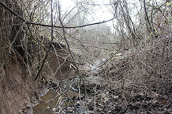
- A deeply incised channel is mostly straight to ensure a relatively constant flow velocity for the down-channel water uses. Most of the channel is City right-of-way, with the exceptions of the channel to the west of SW Allen Street and the portion that flows underground in a culvert on Hollingsworth and Vos industrial site on SE Chapman Place.
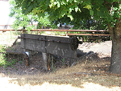
- A secondary sluice gate was constructed near the end of the original channel. This sluice gate was a secondary water flow control and emergency turn-off valve. The secondary sluice gate still exists on the Hollingsworth and Vos industrial property.
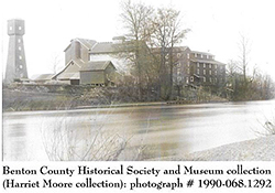
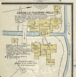
- A mill used the water to power a mill wheel. It was located on the west bank of the Willamette River. The first mill was a lumber mill built under the direction of J.C. Avery. It burned down in the 1850s, and a flour mill was built to replace it. Repeated burns occurred, but there were continuous flour mills in operation on the site, powered by the water of the Mill Race system until 1938. At that point, a new industry began using electricity from power lines to operate the commercial enterprise.
Primary Functional Phases of the Mill Race

Phase #1: Industrial (1852-1938)
For 82 years, the Mill Race system reliably served Corvallis as the energy source of one of its primary industries: milled flour.
Phase #2 – Recreational (1938-1967)
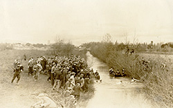
For 29 years, the Mill Race reliably served the Corvallis area as its primary recreational site. In 1938, it lost its founding purpose of powering industrial production. But, in the meantime, it had developed other benefits for the community, well beyond the initial industrial function. In the 1880s, OSU and U of O began “Civil War Tug-of-War Games” over the Mill Race channel. One year, it would be on OSU home territory of the South Corvallis Mill Race. The following year it would be on the U. of O home territory of the Eugene Mill Race. This back-and-forth annual rivalry battle extended for decades.
The community also used the Marys River reservoir and the Mill Race channel for:
- boating
- fishing
- swimming
- games
- picnicking
It was among the principal recreational gathering places for OSU and the entire Corvallis community. Picnics were common along both the reservoir and Mill Race channel banks. A park was developed on the private property of the Tunison family near the dam and channel entrance, and the family let the public use it. That park is now gone, and the current day City-owned Tunison Park is located about ¼ mile to the southeast, well away from the river and channel. So the Mill Race system was primarily a recreation site for the community from 1938-1967. In 1967, the dam was removed, the reservoir vanished, and the flow of water through the Mill Race was reduced to simply draining ground water. As a result, Corvallis lost one of its major recreational sites.
Phase #3: Stormwater/Groundwater Drainage (1967-2022)
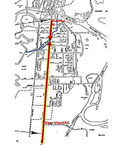
For the past 55 years, the Mill Race has served South Corvallis as a primary drainage channel for stormwater runoff and groundwater drainage. All of 99W drains from Kiger Island Road to the Marys River, a total of two miles. This drainage areas includes highway pavement and the properties immediately adjacent to the highway. This is a lot to ask of a small waterway.
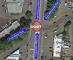
This drainage system works during small or normal annual rainfalls. Unfortunately, during large region-wide storms that cause high waters in the Marys and Willamette Rivers, river water floods down the Mill Race from the Marys River or back up the Mill Race from the Willamette. In the worst cases, the river water floods the Mill Race from both rivers in both directions. When that happens, the extensive stormwater drainage system for South Corvallis completely fails. The stormwater backs up the stormdrain with hydraulic pressure to residential and commercial areas that normally would not flood.
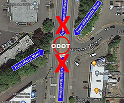
Unless the extensively long stormwater drainage system to the Mill Race along 99W is cut off from the Mill Race and drains elsewhere, South Corvallis flooding will only worsen. Residential and commercial development, coupled with climate change, will only make this drainage system far more dangerous to residents and businesses in South Corvallis.
The Proposal
THE SOUTH CORVALLIS GREENWAY CORRIDOR PROPOSAL is presented in the video below.
Goal
Create Phase #4 for the Mill Race – a contiguous wildlife and pedestrian corridor along the Mill Race that extends from SW Allen Street to the Marys River below the BMX Park.
Project Components:
- Replace non-native plants with native plants, in the riparian corridor
- Nurture greater native species biodiversity and migration pathways
- Construct an alternative transportation pathway for South Corvallis
- Design to advance social equity between the east and west sides of 99W
- Build connectivity between all portions of South Corvallis
- Improve pedestrian safety across roads and highways
- Reduce Mill Race flood impacts on nearby residential and commercial properties
- Divert municipal stormwater drainage from entering the Mill Race
- Partner with the City, ODOT, property owners adjacent to the Mill Race and local organizations to implement the proposal
Benefits
Equity and Safe Connectivity
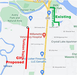
The Corridor will connect along the Mill Race two physically segregated corridors (the proposed Tunison Trail and the Eric E. Austin Memorial Path), each of which serves separate cultural populations. There is currently no safe and convenient pedestrian or bicycle-friendly crossing of 99W to connect the two communities segregated by the state highway. Further development, population growth and economic inequality will further segregate the two sides of 99W unless there is a specific plan to connect the two sides with an effective and engaging safety infrastructure.
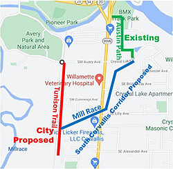
The two segregated corridors that need connecting in the middle of the commercial zone are:
- The Eric E. Austin Memorial Path on the east side of 99W that extends from SW Crystal Lake Drive to SW Allen Street, along the Mill Race in South Corvallis.
- The proposed and partially funded Tunison Trail on the west side of 99W that extends from Tunison Park to SW Allen Street.
Stormwater and Flooding Safety
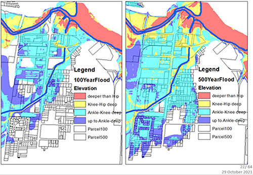
- Restrict stormwater to the Mill Race – The proposal promotes a reduction of stormwater drainage that enters the Mill Race during flood events. Stormwater drains into the Mill Race from as far away as 1.5 miles. It creates hazardous conditions when the adjoining rivers flood, exacerbating flooding in South Corvallis. ODOT is working closely with the City of Corvallis to improve transportation safety along 99W. However, one of the biggest safety hazards remains flooding. ODOT and the City can partner to reduce this safety risk by diverting stormwater away from the Mill Race.
- Reduce depth of Mill Race trench – If stormwater discharge is reduced, then the City and its partners can reduce the depth of the deeply-incised trench. It is not a natural waterway in its current incised condition. The trench depth creates hydraulic conditions that pull Marys River and Willamette River flood waters into the residential and commercial areas of South Corvallis. These conditions can create high safety risks and great economic losses.
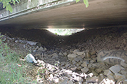
- Elevate 99W Mill Race Bridge – While ODOT is considering its options for providing greater transportation safety on 99W in South Corvallis, it can help to resolve pedestrian and flooding risks by rebuilding the bridge over the Mill Race at a higher elevation. This would reduce the flood restriction and overflow at 99W during flood events. A path could then be developed under the elevated bridge to be used during non-flood events.
Environmental Regeneration
- Increase diversity and biomass of aquatic native fish – An informal survey found native fish in the Mill Race, but most fish were non-native invasive species. Cleaner, cooler water that does not include highway drainage is needed to support native fish. Increasing tree canopy over and adjacent to the Mill Race will cool the water during the warm months for native fish to survive. The Mill Race is too straight, narrow and incised to allow fish habitat. A wider riparian zone is required to allow an appropriate fish-friendly flow pattern to occur.
- Increase diversity and biomass of terrestrial native plants – There are native plants growing in the Mill Race riparian zone. They are, however, overrun by blackberry, English ivy, non-native rose and other invasive, exotic plants that require removal. Native plants are required to provide the food sources and habitat that have evolved over the millennia to support the native fish population.
- Create a contiguous corridor for migration of terrestrial and aquatic fauna to migrate – Many of the native fish species that would inhabit this waterway are the small fry of anadromous fish that migrate seasonally. A contiguous meandering corridor with pools and runs are required to sustain the habitat and food availability for those migrating fish fry. The form of the current trench does not meet those criteria.
Components of a Successful Corridor
- Endorsements by the City of Corvallis government and ODOT – Only with full City government and ODOT endorsements and support can this project become a reality
- City rights-of-way on both sides of the Mill Race must be widened to a distance that allows the following:
- Tree canopy to shade and cool the waterway during hot summer months
- General vegetation and passageway to provide wildlife food and habitat for a biodiverse wildlife corridor
- Pedestrian pathway along the perimeter of the right-of-way
- Vegetative buffer to restrict polluted runoff from adjacent streets and properties into the Mill Race
- Vegetative buffer to muffle traffic noise
- A wider riparian zone can be acquired by the following means:
- Recovering the original right-of-way – Some adjacent private property owners have built over and used the City right-of-way as if it were for their own private use.
- Negotiating – Some adjacent properties will be redeveloped, at which time the City can negotiate for a wider right-of-way.
- Purchasing – Various governmental, organizational and private funding sources can be accessed to acquire adjacent lands for a wider corridor.
- A partnership among the City, ODOT and local non-profit organizations needs to be developed to fund and create the riparian buffer and path.
- Safe pedestrian crossing infrastructure across 99W and Crystal Lake Drive needs to be developed.
Endorsements
The Water Action Team promotes, endorses and pursues ways to forward the concept of a South Corvallis Greenway and Pedestrian Corridor along the Mill Race, The team is joined by the endorsements of the following organizational leaderships.
- Corvallis Environmental Center – Nature and Food Education | Corvallis Environmental Center | Corvallis, Oregon
- Corvallis Sustainability Coalition – Corvallis Sustainability Coalition | Working Together to Create a Sustainable Community (sustainablecorvallis.org)
- Freshwaters Illustrated – Freshwaters Illustrated
- Greenbelt Land Trust – Greenbelt Land Trust
- Marys Peak Group Sierra Club – Oregon Chapter Sierra Club
- Marys River Watershed Council – Marys River Watershed Council | Inspiring and supporting voluntary stewardship of Marys River Watershed (mrwc.org)
Team Accomplishments 2014-2022
- 2012 – Initiated historical and on-ground research on the Mill Race
- 2014 – Partnered with City and other organizations regarding history and research
- 2014 – Planted first riparian native trees along the Mill Race
- 2015, 2019, 2021 – Partnered with other organizations to provide public Mill Race tours
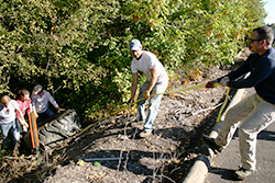
- 2015, 2019 – Removed trash and invasive plants through volunteer work parties
- 2018, 2021 – Planted native trees north of Crystal Lake Drive
- 2018, 2019, 2020 – Cleared riparian zones of non-native plants
- 2019 – Negotiated successfully with local resident who purchased a half-acre riparian property on Bridgeway Avenue along the Mill Race for the purpose of conservation
- 2019 – Negotiated with a landowner to donate land adjacent to the Mill Race to the City. Unfortunately, the City rejected the offer and lost an opportunity to improve the Mill Race system.
- 2020 – Initiated conservation work on Bridgeway Avenue
- 2021 – Endorsed and began promoting the concept of a contiguous corridor pathway along the Mill Race
- 2021 – Provided, recorded and posted a public webinar about the Mill Race titled “South Corvallis Greenway Proposal”
- 2021 – Led guided private tours for City staff, ODOT representatives and non-profit organizational leadership, as well as potential donors to the greenway proposal
- 2020, 2021 – Planted native plant species near Bridgeway Avenue
- 2020, 2021, 2022 – Provided on-going mulching, watering and weeding maintenance of planted areas
2022 Work Plan
- Continue to seek endorsements and active support from the City and ODOT
- Develop a strategy and financial plan for acquiring land to create the corridor
- Design and install the first interpretive display along the Mill Race
- Plant camas and tarweed, which would have grown there prior to 1850
- Weed and mulch young native plants

